Showing posts with label maps. Show all posts

Tuesday, June 15, 2010

Where are people moving to?


Red lines represent moves out of the county and black lines moves into the county. The connections are interesting. There is a lot of red to very populous cities, folks are leaving New Castle County to go to New York, Seattle, San Francisco, LA, Dallas, and Houston. Presumably some are retiring to the Florida counties and to Las Vegas and Arizona. There also seem to be some moves, possibly due to the chemical industry to the Texas coast, New Orleans, Buffalo and Rochester.

There is expected inflow from obvious places like New York, and Philadelphia. I also see what I think is college inflow from Penn State area, Univ of Wisconsin, Univ of Minnesota, Univ of Michigan. All of these are my suppositions. The full data is available at the links below.

Monday, December 21, 2009

Crypto-Catholics - Sun Worshippers at the Winter Solstice?

Every year around Daylight Savings Time in the fall and the time change leaving it in the spring I notice that the sign shines so brightly through the stain glassed window at our church, Immaculate Heart of Mary, that whole sections of the pews are unoccupied because parishioners would be starring straight into bright sunlight only partially filtered by the glass. I have a long term project to map those areas of the church but I need to get in there with a measuring tape to develop a good floor plan to do so.

One thing that I have done is notice the odd position the church has on its lot. It is not straight but on the diagonal. In fact, running a line through the church center and through the stain glassed window in the front of the church as in the diagram above shows that the church is oriented to face 123 degrees on a compass, or almost southeast by east. Why should it have that particular orientation. Using the Planetarium program on my trusty Treo or any website which gives a sunrise at 120 at 8:19am today, suspiciously close to the 123 degrees, give or take, of the orientation of the church.

Or it could be that the church is just facing the corner and its angle bisects the two roads that make up the southeast corner of the lot, Shipley Rd, which is the more north to south road, and Weldin Road which is the more east and west road. I used the New Castle County Parcel Search map function (IHM parcel) to get exact coordinates for the roads. These roads are not exactly aligned to a North, South East West grid or the church would point at 135 degrees (90 plus 45). The roads are canted slightly counter clockwise from the grid, which points the church at the sun. (click the picture below for larger)


The final choice I leave up to my capable readers. Is the church pointed at sunrise on the Winter Solstice in homage to the secret sun worshipping sect that took over the church at the time of Constantine, or is it just pointed aesthetically at the corner of the two roads that define the lots? Conspiracy or coincidence?

(I used the New Castle County Parcel Search and the mapping function there for pictures and maps. I also got some maps, aerial photography and coordinates and much more at the Delaware DataMIL, also click on the Map Lab for customer maps and the coordinate system I used to find the street orientations.)

Tuesday, April 28, 2009

Baseball's Blackhearted Blackouts

I suppose I am late to the historical rant about Major league baseball's controversial television blackout policy. What I am looking for, sparked by my desire to watch baseball when I want and where I want, was the newest map of the MLB blackout areas. I was hoping it would help me to understand the poor implementation of the YES network, MASN and MASN2 on FIOS TV as well as the unnecessarily expensive MLB Extra Innings.

Apparently even MLB.TV on the web blacks out games in your local area because you are supposed to go buy tickets or watch it on the approved local channel. This has caused a lot of angry discussion among fans and commissioner Bud Selig had asked for a review of the policy. MLB.tv should also take back its slogan "Sign up for MLB.TV and never miss a game again!", it isn't true. It doesn't look like the review and changes to the policy occurred in time for this season. Thus the policy is painful and restrictive and doesn't mesh well with this strange new world of the internet. From the article summary:
  • Local Live Blackout: ALL LIVE MLB.TV games will be blacked out in each applicable Club's home television territory (except for certain home television territories for which MLB.com may offer in-market subscription services) or in Japan.
  • National Live Blackout (Regular Season): Due to Major League Baseball national exclusivities, each Saturday until 7:00 PM EST (beginning May 17, 2008 and continuing for remaining Saturdays during the regular season) and each Sunday night (for games that begin after 5:00 PM EST), all scheduled webcasts of games played within such time period will be blacked out.
  • National Live Blackout (Post Season): Due to Major League Baseball national exclusivities, during the MLB postseason, if you live within the following nations or territories, webcasts of all postseason games will be blacked out: United States, Canada, Guam, US Virgin Islands, South Korea and Japan.
  • NOTE: Due to broadcast restrictions, new MLB.TV and Condensed Game archives are limited to a playing time of five minutes in duration until 6 am ET on the day following that on which the applicable game commenced play.
The national blackouts are because either Fox (on Saturday), or ESPN (On Sunday Night) and now MLB Network (on Wednesday's) has exclusive rights to televised games. This also screws up MLB Extra Innings on cable, since many of those games are blacked out according to these rules also.

In my searches I found at least two maps of the blackout areas for the various teams. I also found maps close to but not exactlye blackout maps, whihc were somewhat helpful. They are somewhat similar to the United Countries of Baseball map from Stange Maps.


The maps below are based on some more rigorous data. The unincorporated territories above are certainly incorporated in real life, because there is money to be made, or imagined to be made. Or one could use this map based on survey results.

However, my goal is to find a map generated using official data from MLB and even to find the data myself.
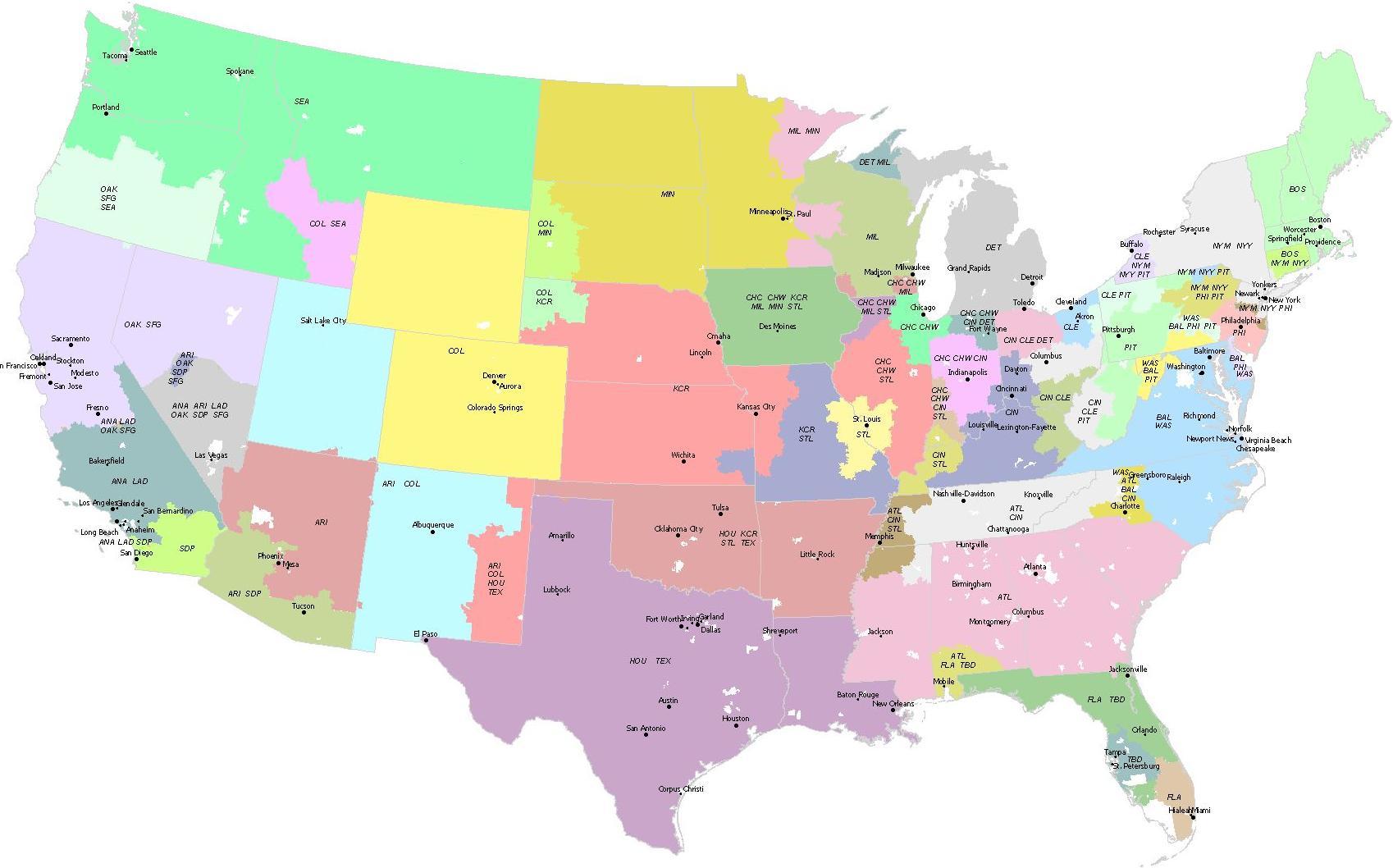


This version (click on pic for bigger) was created by a helpful wikipedia user but does not get correctly credited in many articles on the topic (like here at the Biz of baseball).

I like the version above (click picture above for bigger) from a Yahoo article (map is presented without a credit), that includes the cities and team names so it is clearer when you look at a region. If multiple teams coexist in a region, all of those teams are blacked out on MLB.com or on MLB extra innings, with the expectation that you should watch the game on a local channel. This get really bad in baseball free Iowa, or if your cable company doesn't carry the correct local channel.

One can use the"Am I in a local live blackout region" dialogue box at the bottom of any of the MBT.tv mediacenter pages, to get a list of the blackout zip codes for any of the teams. Picking each team in succession would allow a file to be built and then the right software could map from that. I am surprised that I cannot find a Google maps mash up that does just that. I now have a list of all of the teams and their respective blocked out zip codes, I now need a list of every zip code with its lat. and long. and perhaps the population for fun, and I could make my own maps.

Sunday, March 30, 2008

Google Maps Street View van stops at McDonalds on the way up Concord Pike

I was using the new Google Maps Street View to check that I had the correct gas station on Concord Pike (202) north of Wilmington the other day and I discovered something humorous. Normally the street view just shows the view progressing step by step along the road. As I "travelled" up Concord pike with street view we suddenly turned into the McDonald's and went through the drive through. It was unexpected. The Google Maps software thought that we were on 202 and the official yellow line that indicates the street also says Concord Pike, but you can clearly see that they went to McDonald's. The animated gif below shows the detour.

avatars myspace at Gickr.com


At Google Maps, you can see the street view just before the McDonald's, and then in the drive through. You can click on the arrows in the links to duplicate the path in the animated gif. I never would have found this except by accident.

I guess they got hungry. Looking up and down Concord Pike in street view shows that they turned into the parking lots a few times.

Monday, November 05, 2007

Crazy Blue Hen Delaware News Roundup - now with Pumpkins and Dolls

Just where does Delaware end anyway?

This roundup may or may not be coming to you from Delaware, as the state battles with New Jersey over the location of the Delaware River state line boundary. It is not in the middle of the river as you might think. Penn's Grant actually places the Delaware boundary right at the water line on the New Jersey side and this has caused all sorts of problems with a natural gas loading facility - in the river - that companies on the New Jersey side of the river want to put in. Should there ever be an accident it would certainly be felt on the Delaware side of the river, by most of Wilmington, for instance. For environmental and safety reasons, Delaware has said no and the court battle has begun anew, this time all the way to the Supreme Court. You can learn more about the border here. It is quite interesting that Delaware has all of the say about what New Jersey can put in the water along that particular stretch of river.

Mystery Dolls of the Delmarva peninsula

Someone is delivering dolls to the front porches of Dewey, Delaware homes. No one knows who it is. I am sure that it is harmless, but in this day and age of unthinking paranoia, why would anyone think that this is a good idea. If we throw good sense and reality to the wind then we can worry about killer dolls like Chucky and that scary clown from Poltergeist. Leave the dolls at home, people!

Pumpkins fly to their doom.

Have you ever heard of Punkin Chunkin? If not you can't be from Delaware. Every November for 22 years, teams from all over the country compete in lower Delaware with home built machines to fire a pumpkin the farthest distance. This year's winner fired a pumpkin 4,211 feet! Just let that soak in a little - a ten pound pumpkin shot almost a mile. The prevailing technology is air cannons, but there are other classes for catapults and trebuchets, and different age groups. The pumpkin must stay intact until impact. If it blows apart during launch it doesn't count and is called a "pie".

Punkin Chunkin is really just another local festival with extra technology that adds spice to living in Delaware.

Wednesday, August 01, 2007

When did they redirect Shellpot Creek?

As I delved into the old maps of Shellpot creek looking for previous names I realized that as late as the 1930's, Shellpot Creek emptied into the Brandywine Creek not directly into the Delaware River as it does today. In fact that whole area around this connection was the Cherry Island Marsh, which may have made the difference between creek or river and marsh a subtle one.

The University of Delaware Research and Data Management Services, the Delaware Geological Survey (DGS) and the State of Delaware Department of Technology and Information (DTI) have developed a great site for all kinds of Delaware mapping information called the Delaware DataMIL, for Data Mapping and Integration Laboratory. Clicking on the the Map Lab button opens a window (Internet Explorer only!) with dynamically generated maps with all kinds of data layers. My favorite is the Aerial Imagery going back to 1937. The animated .gif (thanks Gickr) shows the connection between Shellpot Creek and Brandywine from 1937, 1954, 1961, 1968, 1992, 1998 and 2001.


It is interesting to watch the sudden appearance of I495 , the growth of the water treatment plant and ponds and all of the growing development in this section of Wilmington as the years click by in the animated gif. Watch closely and you can see the Shellpot creek connection to the Brandywine was severed between 1937 and 1954.

Using these pictures we can see that between 1937 and 1954 (from the first two pictures in the animated gif, zoomed in below, water outlined in blue),

1937


1954

the land between the Shellpot creek outlet and the Brandywine was filled in for a road to extend 12th street to the railroad yard and eventually to an exit for I495 . Shellpot creek was redirected to the Delaware river. I will eventually find a newspaper article or building planning records that references this change, but for now the aerial photography is very helpful.

Saturday, February 03, 2007

Is there a wedge between Delaware and Pennsylvania?

The title wedge is cartographically speaking as opposed to argumentatively speaking. Technically the answer is now "no" since that was all cleared up in 1921.

Strange Maps and Mike's Musings take on the weird border between Delaware, Pennsylvania and Maryland over a few posts. I know I have bored many a group at a cocktail party with the trivia that Delaware is east of the Mason-Dixon line (The border is the lesser known North-South running line besides the one familiar as the southern border of Pennsylvania).

Also interesting is that the western boundary of Delaware is not exactly a straight line, some of that famous 12 mile circle pokes the border out into Maryland a little. Whereas for me this map stuff is more of a hobby, Mike has turned it into a career.

On a side note, I seem to have fallen off of Mike's Musings Delaware blog list. I wonder if I haven't been "Delaware" enough, talk to much about stuff that has nothing to do with Delaware (which is a lot of things) or said something to offend. I've been here for 16 years, I could pass as a native for a spy mission to another state if you need me to. We all have to stick together if we want to avoid an unSeparation Day.

(this shameless ploy did work for Galaxy Girl).

(notes: Separation Day, June 15, 1776, was the day the colonial General Assembly declared Delaware an independent state, I know that you all didn't know that)

Monday, January 01, 2007

Your house location in historical context

I have always been fascinated with what was where my house is before my house was there. The last house I lived in was built on land that belonged to a cemetery. They didn't have to move the bodies, because as far as I could tell they had never buried any on the land.

My current house is a lot younger than that one, but is quite close to another cemetery that has some historical significance for Delaware. In 1687 Valentine Hollingsworth, a contemporary of William Penn, and a early settler of Delaware (then part of Pennsylvania!) donated one-half acre for a burying place, “being some already buryed in ye spot.” The plot was near the Newark Union Meeting of Friends (Quakers).

Valentine Hollingsworth himself is supposedly buried in the cemetery, and there is a monument, erected in 1935, to commemorate him.


The earliest readable gravestones I could find were in the 1800's. I did find a stone in the wall surrounding the cemetery which reads 1787.


The Delaware Geological Survey, headquartered at the University of Delaware has links upon links of Delaware information and also has maps of the Delaware Hundreds. Hundreds are an old way of dividing the state. I found the Newark Union Cemetery on the Brandywine hundred map from the Pomeroy and Beers Atlas of 1868 (.pdf link). Here is an excerpt (the square labelled Cem Union Ch at right).

Having a historical marker as far back as 1687, which is almost as far back as you can go in Delaware, plus the geographical marker of Shellpot Creek right out back makes it convenient when locating the house location through history. I can just imagine Hollingsworth crossing the Shellpot Creek right where my house is now, all those hundreds of years ago.